


Direct conrol system of air means
Appointment
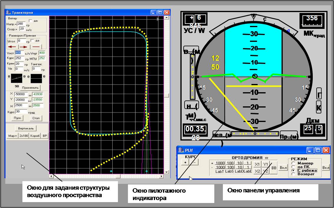
DCS is intended to generate command control signals to the aircraft (helicopter) to keep the aircraft on a given flight path and altitude during the flight by the route, arrival actions for landing on a given special area in standalone mode.
When combined with the Early Warning System to be closer to the earth - Implementation of the optimal flight path traversal (rounding) of obstacles or areas of dangerous weather conditions.
The equipment
1. Aerobatic display control:
- Color LCD 100 × 120 × 70 mm;
- Computer module;
- keypad;
2. Module GNSS (GPS) and the antenna:
Aircraft Control Modes:
• Manual, director, automatic;
Modes of Operation
• “Route”, “return”, “landing”, “re-entry”, “relief”;
The calculation of the flight with route or track approach:
- Automatic and continuous indication of the location of aircraft in the polar and geographical coordinates;
- An indication of the line specified paths (flight path) of the aircraft to exit it at the optimal trajectory;
- Signaling when aircraft comes through the given checkpoint;
- Operational data typing a new specified route point again when the flight path was changed (bypassing the severe weather, etc.);
- Ensure aircraft input in the starting point to come near to a given trajectory (initial stage);
- Signaling when the aircraft comes near to the minimum safe altitude of the stages of the route;
- Calculation of wind direction and speed (automatic or on request);
- Display the current estimated navigation data taking into account the drift angle;
- An autonomous the definition of bearing on a given airport (platform);
- An autonomous definition of altitude, route speed and track angle with the magnetic board systems failures during the flight on the route;
- Forecast the trajectories of aircraft and some of the navigation parameters in the absence of signals of GNSS.
Construction of the landing maneuvers:
- Landing (second landing) on the selected path;
- Calculation of the trajectory of landing at the lower rate of precipitation;
- Display of the landing maneuver location of aircraft;
- Select the type of glide path taking into account maneuvering of aircraft;
- Set and alarm the minimum safe altitude at the aerodrome;
- Displays current estimated navigation data of the given line rate, the glide path and the current distance to touchdown;
- An autonomous definition of altitude, ground speed and track angle with the magnetic board systems failures during landing;
- The distance forecast to touchdown in the absence of signals of GNSS;
- Detection of early landing and a warning about the crew in accordance with the requirements.
Combination with an early warning system to be closer to the earth:
- Form the direct control command when crawling (rounding) of the terrain on the most favorable trajectory;
- Prevent collisions with obstacles - the calculation of the optimal trajectory traversal (rounding) of obstacles when alarm was triggered such "Ahead of the earth» («Terrain Ahead») or "In front of an obstacle» («Obstacle Ahead»);
- Alarm on roll values limit “Roll is large”;
- Jeppesen database information.
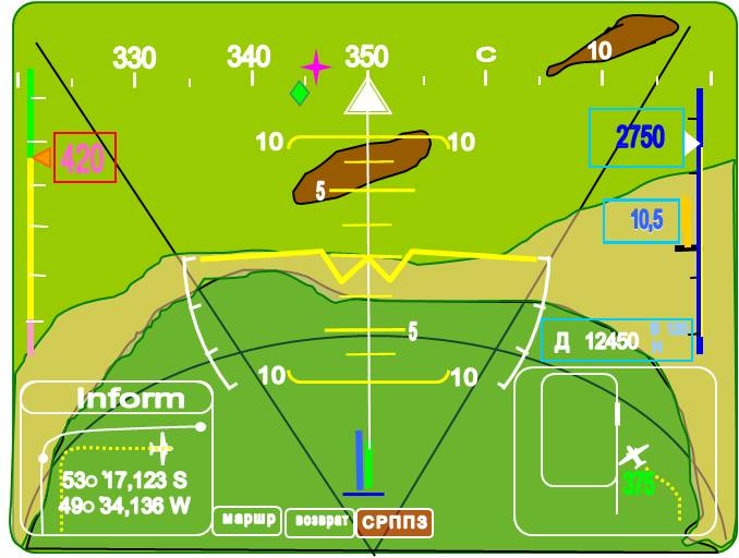
Small-sized color LCD display:
.jpg) Diagonal 5 ";
Diagonal 5 ";- Resolution of 640x480;
- 256 colors;
"DCS - operation modes"
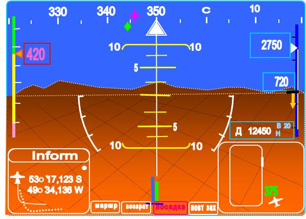
Mode "Landing" – when aircraft comes to the landing course on the shortest path, maintaining the set lines of the course and glide path of the programmed airfield, the site for special purposes.
- Director signal to complete rotation in the direction of the landing course to low aircraft by the glide path;
- Keep the roll which needs for a self-centering in the direction;
- Zero-director position of the arrow in flight through the PC;
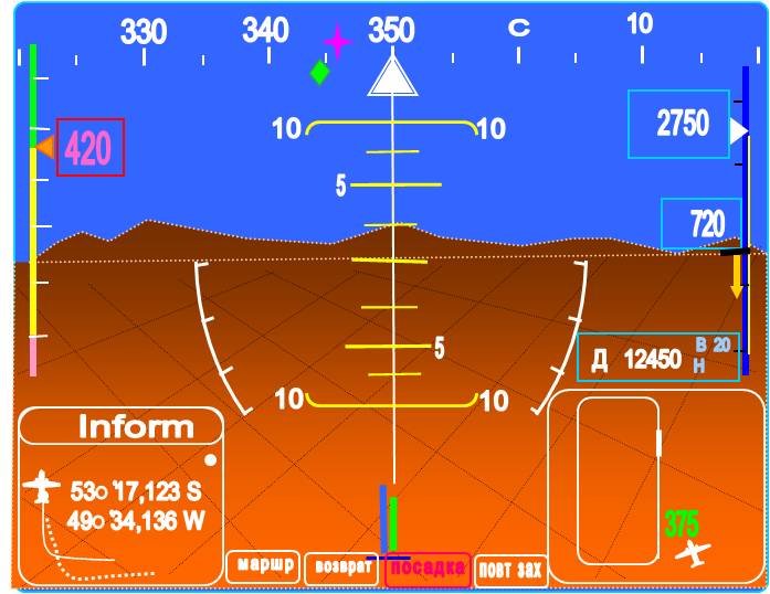 «The roll is large» («roll limit») - Signaling the limit values of the roll and position the arrow-director;
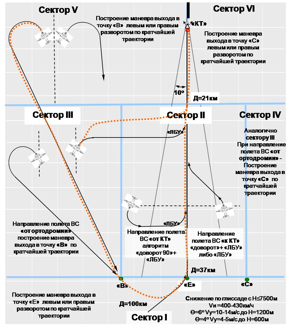
Mode "Return" - Automatic algorithm selection for maneuver depending on the aircraft position and direction.
- Construction of trajectory by a 6-sector approach to the final stage to land;
- Pre-exit out to pre-empt point to come to landing with distance of 37 km;
- Low the aircraft along a trajectory cloud punch (θ = 4 - 6 ).
Mode "relief"
- Form the director bypass commands (rounding) of the terrain on the most favorable trajectory;
- Display sector-radial map of the terrain at the course of the flight;
- Display the alarm and warning information.
Interface
- Preliminary skill getting of approach flight by the path and landing and allocation of attention in the director control mode in the simulation GNSS signal (GPS).
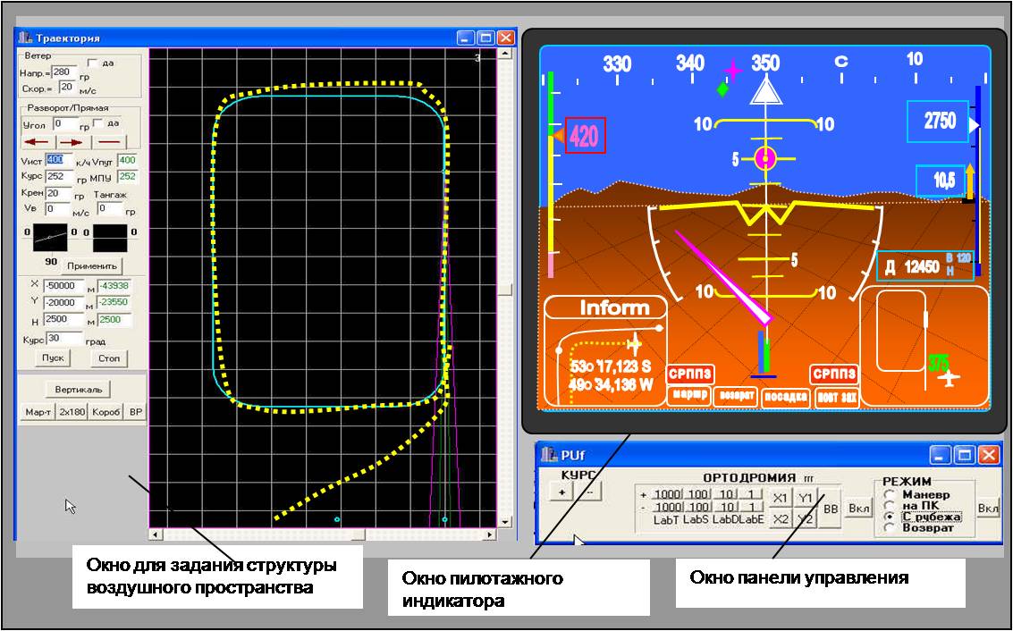
- Adaptation of the interface under aircraft equipped
.